The Yarra Valley, Victoria's oldest wine region, and the Dandenong Ranges, where the lush eastern suburbs of Melbourne meet the mountains and woods, make up this area to the east of Melbourne.
Over 80 wineries can be found in the Yarra Valley, which is located to the north-east of Melbourne. These vineyards can be found in the areas of Lilydale, Coldstream, Yarra Glen, Healesville, and Seville. In 1838, grapes were originally planted at Yering Station, and now the Yarra Valley is widely regarded as one of Australia's premier cold climate wine districts.
In addition to selling wine and providing picnic areas, many of the region's vineyards also provide other amenities including restaurants, cafés, and even boutique hotels.
The Yarra Valley is home to renowned family-friendly destinations including the Healesville Sanctuary and several bushwalking paths, fruit farms, markets, and galleries.
North-east of Healesville, on the Maroondah Highway, is a place called Black Spur, known for its towering trees and lush vegetation. Nearby, Marysville serves as an entry point to Lake Mountain, a popular ski resort.
The Dandenongs, or The Dandenong Ranges, are a series of valleys and hills covered in lush temperate rainforest and dense ferny vegetation. Extensive routes wind through the thick greenery, making it a bushwalker's and cyclist's dream.
From the top of Mount Dandenong, visitors can take in sweeping vistas of the city below, and the charming communities in the area are home to everything from boutique hotels and restaurants to art galleries, farmers markets, and day spas. Between Belgrave and Gembrook, you may ride the famous Puffing Billy steam locomotive and take in the beautiful scenery along the way. Enjoy a change of scenery in one of Victoria's most picturesque locations while yet being less than an hour from the bustle of Melbourne.
FAQs About Melbourne
With over eighty vineyards dispersed throughout Healesville, Coldstream, Yarra Glen, Seville and Lilydale, the Yarra Valley is Australia's premier cool-climate region, and is renowned for Chardonnay, Pinot Noir, Cabernet Sauvignon, Shiraz, and méthode traditionnelle sparkling.
Greater Dandenong is home to some of Melbourne's greatest places to eat. Known as a destination for food lovers and is home to a large range of cuisines such as Afghan, Indian and Asian. A great to experience the food and culture is to go on a Cultural Food Tour.
Belgrave
Located midway between Emerald and Ferntree Gully, Belgrave is a prominent town in the Dandenong Ranges.
The Burwood Highway connects Belgrave to the rest of Melbourne. The last half kilometre or so of this road is known as Main Street, and it winds closely through the town's main business district, which is surrounded by trees and has a variety of restaurants, souvenir stores, and the historic Cameo Cinema. Ascend the ramp-up to the Belgrave Town Park, on the north side of the main roundabout, for a high perspective over the town centre.
One of Belgrave's greatest attractions is the Puffing Billy steam locomotive. It is the oldest operational steam locomotive in Australia, offering passengers on a scenic excursion through the thick woods and fern valleys of the Dandenong Ranges. Travelers have the option of hopping off at any of the stops along the route, including Menzies Creek, Em, Gerald, and Lakeside, or continuing on to Cockatoo and Gembrook, the last two stops in the route's 25-kilometer length.
You can have lunch and supper, and even use the dining car if you choose. A large wooden trestle bridge carries the railway line over the surrounding creek and roads, making the viewing point on Gembrook Road little over a kilometre east of Belgrave one of the greatest places to see Puffing Billy on its voyage.
Belgrave Lake Park is located south of the town centre on Park Drive, and it has a tiny abandoned reservoir on Monbulk Creek. The park contains walking routes, BBQ facilities, a playground, and a grassy oval, all amid a tranquil and densely forested setting.
The Birdland Reserve is located in the nearby residential area of Belgrave Heights, just off Mt Morton Road. This park has a network of lakes, wetlands, well-maintained walking routes, and picnic/BBQ facilities along the banks of Monbulk Creek. Following Mt Morton Road farther south leads to the Baluk Willam Nature Conservation Reserve. It is next to the beautiful Mount Morton Reserve and has a significant collection of native plants.
From Belgrave, you can easily visit the neighbouring Dandenong Ranges National Park, as well as the charming nearby settlements of Kallista and Olinda, and the highest point in the ranges, Mount Dandenong.
Cockatoo
Cockatoo, nestled in the Dandenong Ranges between the cities of Emerald and Gembrook, is a beautiful place to visit. Along a steep stretch of McBride Street is where you'll find most of Cockatoo's business activity. Here you can find anything from a tiny grocery to a variety of cafés and other dining options.
Passing through the heart of town on a regular basis, the Puffing Billy tourist railway line passes close to the shops at the bottom of McBride Street, bringing back nostalgic memories of steam train riding.
There is a wide variety of sports facilities available in Cockatoo. Bowling alleys, basketball courts, tennis courts, and other sports facilities along the west side of Pakenham Road in the town centre. Indoor stadium, oval, athletics track, and netball courts make up the Cockatoo Sports Complex on Mountain Road. Cockatoo has many options for bushwalkers, including the nearby Wright Forest. A series of hiking trails wind their way through the natural bushland, with the primary entry locations being off Bailey Road and Wright Road.
Cockatoo is located in the beautiful Dandenong Ranges, making it the perfect jumping off point for a number of breathtakingly beautiful drives. South of town, through beautiful rolling fields, is Paternoster Road, and a trip down the unmade Phillip Road will take you through some of the town's very profitable agricultural districts.
Southbound on Pakenham Road, you'll pass through towering eucalypt trees as you follow Cockatoo Creek. Things begin to open out as you near the little town of Mount Burnett. And the northbound route to Woori Yallock winds its way across green pastures and picturesque mountain peaks.
Emerald
Situated between Belgrave and Cockatoo in the beautiful Dandenong mountains is where you'll find Emerald. The business districts of Emerald are split in two. The longer of the two centres runs from the top of Puffing Billy to the playground and train station at the bottom of Kilvington Drive.
A smaller centre with cafés, gift shops, a big supermarket, the town hall, and the library can be found little under a kilometre away, between the roads that go to Monbulk and Beaconsfield, and look out over the Worrell Reserve sports facility.
If you're looking for a place to relax and have fun, go no farther than Emerald Lake Park. In the late 1890s, it was a part of the famous Nobelius Nursery, where fruit and decorative trees were planted and flourished in the Emerald area's fertile soil. Fifty hectares of the original nursery were made available to the public as a park in 1941.
Picnic areas and gorgeous bushland surround Lakes Treganowan and Nobelius at this park, which is flanked by the Puffing Billy railway line and provides a variety of activities for the entire family.
Aura Vale Lake, located west of Emerald on Wellington Road, is an important element of the complex drainage network that feeds into the nearby Cardinia Reservoir. Picnic Spots at the Henley include lawns and picnic areas that stretch down to the shoreline, as well as a boat ramp for the launching of small, non-powered boats.
The western end of Cardinia Reservoir, near the dam wall, is where Wellington Road begins, marking the beginning of Cardinia Reservoir Park. A significant portion of Melbourne's water comes from this reservoir, which was built and filled in 1973. Kangaroo Flat, Crystal Brook, and Duffys Lookout are just few of the many picnic spots that dot the park that stretches along the dam wall and spillway, and each one has its own shelter, barbeque, and restrooms.
Fine views over the vast waters of this reservoir and down to the lawns, parks, and surrounding shrubbery may be had from a boardwalk that stretches over 2 kilometres along the top of the dam wall and connects the observation car park with the spillway car park.
Healesville
East of Yarra Glen and north-east of Lilydale, in Melbourne's beautiful Yarra Valley, lies the town of Healesville.
The town of Healesville was first established in 1864, and it saw rapid expansion when a railway was built through the region to the flourishing Woods Point goldfields. The advent of the railway in 1889 changed Healesville from a farming and wood industry community into a popular vacation spot for Melburnians.
Healesville, in the renowned Yarra Valley wine area, is a popular vacation spot today.
Wineries, orchards, and berry farms dot the undulating hills and mountainous landscape that surround the city.
West of the racetrack, along Yarra Glen Road, you may take in beautiful vistas of Healesville, Mount Riddell, and the surrounding valleys. Several orchards and berry farms dot the landscape as you make your way north along St. Leonards Road and Myers Creek Road.
Nicholson Street, a tree-lined avenue in the heart of Healesville, is home to several restaurants, hotels, and stores, as well as a contemporary retail complex anchored by a huge supermarket.
The Maroondah Reservoir is located just to the north-east of town, and it has beautiful gardens, barbeque pits, and picnic spaces, as well as a trail along the dam wall that affords breathtaking views of the mountains in the vicinity. Healesville Sanctuary, located only four kilometres south of the town centre, has been welcoming visitors since 1934 and is home to a wide variety of native birds, animals, and reptiles. Located three kilometres east of Healesville Sanctuary, Badger Weir Park has a weir, manicured picnic spots with rotundas, and walking pathways through fern gullies and woodlands. The route from Black Spur on the Maroondah Highway north-east to Marysville is a popular picturesque drive because of the area's lush woodlands.
Lilydale
A suburb of Melbourne, Lilydale is near the northern extremity of the Dandenong Ranges, on the city's eastern outskirts. Yarra Glen and Healesville, both close by, are popular tourist destinations because of the Yarra Valley's abundance of wineries and orchards. Around one kilometre of Main Street serves as Lilydale's business hub, with most stores located off to the side on service lanes bordered by trees and groomed garden strips. Both the Lilydale Village Shopping Centre, which faces Main Street, and the larger Lilydale Marketplace Shopping Centre, which faces Hutchinson Street, can be found in the suburb of Lilydale.
Tree-lined Castella Street is home to some of Lilydale's oldest buildings and landmarks. Historic buildings in Lilydale include the courthouse (1876), the Athenaeum (1888), and the museum housed in the former shire offices (constructed in 1889) that are now a theatre.
Lilydale is home to a number of beautiful parks and gardens. The biggest is found in the area of Lillydale Lake and stretches down Olinda Creek to the Hull Road Wetlands at the crossroads of Hull and Swansea Roads. Melba Park is a beautiful green space that can be found between Market Street and Chapel Street. It has a playground, picnic tables, and BBQ pits.
In Eyrefield Park, located along Hardy Street only one block back from the shops on Main Street, you'll find a walking track besides Olinda Creek, a skate ramp, tennis courts, a bowling club, and a racetrack for model radio-controlled vehicles. There are other athletic facilities available at the Lilydale Recreation Reserve, such as a football pitch and a swimming pool.
Yarra Glen
A picturesque village on the Yarra River, Yarra Glen may be found north of Lilydale and west of Healesville. The Grand Hotel, erected in 1888, is a notable landmark in the tree-lined business district of Yarra Glen along Bell Street. The Yarra Glen Shopping Centre, located farther north along Bell Street, overlooks parks and lakes close to Pinoak Drive.
The northern bank of the Yarra River is home to a recreation reserve that has the town's showgrounds, sports ovals, and picnic spaces; it is a beautiful place to visit in the fall. The town itself is located in the lush Yarra Valley, which is also home to several wineries. Victoria's first vineyard is located just south of the downtown area on the Melba Highway; Yering Station has stunning gardens, a winery complex, and the historic Chateau Yering (constructed in 1854) that today serves as a hotel and eating establishment.
De Bortoli winery may be reached from the Melba Highway by continuing north from Yarra Glen and then turning west onto Dixons Creek. Over 240 acres of vines, a tasting room, a restaurant, and beautifully manicured grounds make this winery one of the biggest in the area. Located west of Yarra Glen in the neighbouring Christmas Hills is the Sugarloaf Reservoir, which has a number of picnic and BBQ spots, walking routes, and lookouts at the dam wall.
Marysville
Marysville is a small town in Victoria, Australia, nestled in the Great Dividing Range's dense forests not far from the Maroondah Highway between the towns of Healesville and Alexandra. Marysville has always been a favourite vacation spot because of its picturesque and tranquil setting, particularly during the spring's beautiful flowering season and the fall's vibrant foliage.
Gold was found there in the mid-1800s, and the village quickly developed into a popular destination for newlyweds seeking peace and quiet in the midst of natural bush and waterfalls.
Marysville is located on the banks of the Steavenson River, which winds through the heart of town and is surrounded by beautiful parks and gardens. Gallipoli Park is located on the banks of the river and has manicured gardens, barbeque pits, covered pavilions, a lake with fishing platforms, a historic water wheel, several children's play structures, a sports oval, a community centre, and a network of walking paths.
Marysville's downtown stretches along Murchison Street, a tree-lined boulevard built to complement its natural setting. On one side of the road, the traditional gutters have been replaced with a winding rocky streambed planted with wild grasses and dotted with bridges that connect to storefronts.
Next to the Steavenson River in Darwin Street's park is where you'll find the town's only grocery. Steavenson Falls is located three kilometres south of the town centre, along Falls Road. It has a drop of around 84 metres, making it one of the tallest waterfalls in Victoria. From the parking lot, you may take the well-formed and level 350-meter path to the falls, where there are various vantage points. From sunset to 11 p.m. every night, a hydroelectric turbine generates enough energy to illuminate the falls in floodlight.
Many of the trails you'll find when bushwalking around Marysville were formerly timber tramways used to transport logs to nearby sawmills, making the region an excellent destination for outdoor enthusiasts. Keppels Lookout, which can be reached by car via Paradise Plains Road or on foot from either the town centre or Steavenson Falls, is renowned for its breathtaking panoramas over the Marysville region's scenery and woodlands. From the summit of Mount Gordon Road, which can be reached from the highway between Marysville and Narbethong, you can take in some breathtaking scenery.
Just to the east of town, on Woods Point Road, lies the scenic Lady Talbot Drive that many visitors enjoy. Included in this tour are the picturesque 4-kilometer Beeches Rainforest Walk through ancient rainforests with many trees over 300 years old, as well as the breathtaking Phantom Falls, Keppel Falls, Taggerty Cascades, and centre Beeches.
Lake Mountain, located about 25 minutes' drive east of Marysville, is 1,433 metres high and has breathtaking views of the Victorian Alps. Cross-country skiing is available on the mountain during the winter months, while the rest of the year, tourists may enjoy magnificent bushwalks along the ski paths. Buxton, located 11 kilometres north of Marysville, is on the banks of the Steavenson River and near the southernmost extremity of the mountainous Cathedral Range State Park. There is a trout and salmon farm in Buxton, as well as a hotel, general shop, and a lovely park along the river.
Montrose
The Mount Dandenong Tourist Road begins its picturesque trek into the mountains in Kalorama, which makes Montrose the northern entry to the Dandenong Ranges National Park. Near the beginning of the Mount Dandenong Tourist Road, at the enormous roundabout, you'll find Montrose's commercial centre, a small retail complex.
This commercial district is set against a picture-perfect background provided by the towering summits of Mount Dandenong and Mount Corhanwarrabul. Also nearby on Leith Road and tucked into a residential enclave on Stradbroke Road are smaller commercial centres.
Montrose Town Center is located between Leith Road and Swansea Road, on the northern side of Mount Dandenong Tourist Road. There is a public library there as well as a performing space for things like concerts and plays. Landscaped grounds surround the Montrose Town Centre and contain a war monument and Robert Riddett's home, originally constructed in the area in 1877 and moved to its current location.
Through the grounds runs the Montrose Brickworks Heritage Trail, a memorial to the town's one and only major enterprise in the 1920s. Educational markers along the path have been made using bricks used in the area.
Parks, reserves, and athletic fields abound in Montrose, giving amenities like ovals, tennis courts, bike paths, and equestrian trails. Homes in Montrose may be found along winding streets shaded by towering gum trees and surrounded by lush local greenery. Montrose's proximity to Melbourne's densely populated eastern suburbs is belied by its picturesque mountain background, ample open space, and the sense of a mountain hamlet.
Lilydale, a short drive north of Montrose along Swansea Road, is the entry point to the Yarra Valley's renowned wine regions.
Read more about this topic athttps://www.travelvictoria.com.au/.
Yarra Valley & Dandenong Ranges
Discover
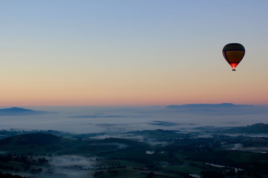
Visit the Yarra Valley's Healesville Sanctuary for a balloon ride, a chance meeting with a platypus, and some great food and wine. Walk the trails, explore the towns, and unearth the Dandenong Ranges' best-kept secrets as you pass through picturesque winding roads, an abundance of artist studios, artisan businesses, and world-famous gardens.
Yarra Valley wine region
Overview
The Yarra Valley is a lovely, cool-climate location just outside of Melbourne, and it is home to a wide variety of cellar doors, from grand architectural statements to modest tin shelters concealed amid the vines.
Stunning Scenery With Wines to Match
In the picturesque hill region around Healesville, Nillumbik, Hurstbridge, and Kangaroo Ground, you can find over 70 wineries producing world-class cool-climate wines. Stop by the wineries of perennial favourites like DeBortoli and Fergusson as well as up-and-comers like Punt Road and Mandala Wines.
The Wine Region That Started It All
Try the grapes from the area that sparked Victoria's wine industry in 1838 and think about the perfect balance between the varied soils, moderate climate, and hard work of generations of vignerons. Pair the region's top estate wines with a lunch at a vineyard restaurant in the area, where you can expect to find a roster of Michelin-starred cooks.
Healesville Sanctuary

Just an hour from Melbourne, in the picturesque Yarra Valley wine area, you can get up up and personal with native Australian animals. You may witness koalas, kangaroos, platypus, dingoes, wombats, emus, and more as you stroll along serene trails in Australia. Come see some of the world's most impressive raptors and parrots at Spirits of the Sky, a breathtaking bird show.
Visit the Australian Wildlife Health Centre and meet the veterinarians and nurses who provide treatment for ill, wounded, or orphaned native Australian species.
On weekends, during Victorian Government school vacations, and on Victorian public holidays, children under the age of 16 are admitted free of charge. Each and every day of the year, visitors may stop by Healesville Sanctuary between the hours of 9:00 AM and 5:00 PM.
Guests and members alike are reminded that prior online ticket purchases are required to enter the Sanctuary. There is a strict limit on the number of people who may enter the zoo and sanctuary at one time, therefore everyone, including toddlers and Zoo Members, must purchase a ticket in advance to enter. Tickets for zoo members are free, but they must be reserved in advance online. Please be aware that everyone, including infants and toddlers, needs a ticket in advance.
Cost:
- Prices range from $19.00 to $38.00
- Adult: $38. Low income: $29. Senior: $34. Complete ticket policies may be found on the website.
- Child: $0.00 - $19.00
Daily rate for children throughout the week: $19.00 (note: 4-15 years enter free on weekends, public holidays and school holidays). On weekends, public holidays, and school holidays declared by the Victorian Government, admission is free for all children under the age of 18. Kids under the age of three go in free every day.
Opening hours:
- Daily: 9:00am - 5:00pm
Accessibility:
- For information about our accessible facilities, please call the operator.
Facilities:
- Convenience Store Car Park Cafe
- Storage for buses
- Venues for large-scale gatherings and conventions
- Center for Interaction
- Read more about this topic at https://www.visitmelbourne.com/.